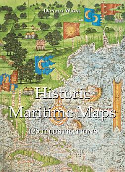
Historic Maritime Maps 120 illustrations
2022 ж. жел. · Parkstone International
3,5star
2 пікірreport
Электрондық кітап
108
бет
family_home
Жарамды
info
reportРейтингілер мен пікірлер тексерілмеген. Толығырақ
Осы электрондық кітап туралы ақпарат
In the Middle Ages, navigation relied upon a delicate balance between art and science. Whilst respecting the customs and the precautions of their forbearers, sailors had to count on their knowledge of the stars, the winds, the currents, and even of migratory flights. They also used hand-painted maps, which, although certainly summary, were marvellously well-drawn. In following the saga of old sailors, from Eric Le Rouge to Robert Peary, Donald Wigal leads us in discovering the New World. This magnificent overview of maps dating from the 10th to the 18th centuries, often ‘primitive’ and sometimes difficult to understand, retraces the progress of cartography and shows the incredible courage of men who endeavoured to conquer the seas with tools whose geographical accuracy often left much to be desired.
Бағалар мен пікірлер
3,5
2 пікір
Осы электрондық кітапты бағалаңыз.
Пікіріңізбен бөлісіңіз.
Ақпаратты оқу
Смартфондар мен планшеттер
Android және iPad/iPhone үшін Google Play Books қолданбасын орнатыңыз. Ол аккаунтпен автоматты түрде синхрондалады және қайда болсаңыз да, онлайн не офлайн режимде оқуға мүмкіндік береді.
Ноутбуктар мен компьютерлер
Google Play дүкенінде сатып алған аудиокітаптарды компьютердің браузерінде тыңдауыңызға болады.
eReader және басқа құрылғылар
Kobo eReader сияқты E-ink технологиясымен жұмыс істейтін құрылғылардан оқу үшін файлды жүктеп, оны құрылғыға жіберу керек. Қолдау көрсетілетін eReader құрылғысына файл жіберу үшін Анықтама орталығының нұсқауларын орындаңыз.