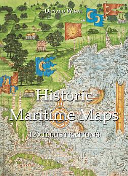
Historic Maritime Maps 120 illustrations
des. 2022 · Parkstone International
3,5star
2 umsagnirreport
Rafbók
108
Síður
family_home
Gjaldgeng
info
reportEinkunnir og umsagnir eru ekki staðfestar Nánar
Um þessa rafbók
In the Middle Ages, navigation relied upon a delicate balance between art and science. Whilst respecting the customs and the precautions of their forbearers, sailors had to count on their knowledge of the stars, the winds, the currents, and even of migratory flights. They also used hand-painted maps, which, although certainly summary, were marvellously well-drawn. In following the saga of old sailors, from Eric Le Rouge to Robert Peary, Donald Wigal leads us in discovering the New World. This magnificent overview of maps dating from the 10th to the 18th centuries, often ‘primitive’ and sometimes difficult to understand, retraces the progress of cartography and shows the incredible courage of men who endeavoured to conquer the seas with tools whose geographical accuracy often left much to be desired.
Einkunnir og umsagnir
3,5
2 umsagnir
Gefa þessari rafbók einkunn.
Segðu okkur hvað þér finnst.
Upplýsingar um lestur
Snjallsímar og spjaldtölvur
Settu upp forritið Google Play Books fyrir Android og iPad/iPhone. Það samstillist sjálfkrafa við reikninginn þinn og gerir þér kleift að lesa með eða án nettengingar hvar sem þú ert.
Fartölvur og tölvur
Hægt er að hlusta á hljóðbækur sem keyptar eru í Google Play í vafranum í tölvunni.
Lesbretti og önnur tæki
Til að lesa af lesbrettum eins og Kobo-lesbrettum þarftu að hlaða niður skrá og flytja hana yfir í tækið þitt. Fylgdu nákvæmum leiðbeiningum hjálparmiðstöðvar til að flytja skrár yfir í studd lesbretti.