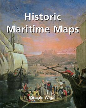
Historic Maritime Maps
Feb 2022 · Parkstone International
5,0star
1 ulasanreport
eBook
256
Halaman
family_home
Memenuhi syarat
info
reportRating dan ulasan tidak diverifikasi Pelajari Lebih Lanjut
Tentang eBook ini
This book presents a selection of oceanic charts dating from the 13th to the 17th century. Though to us they may appear rudimentary, they bear excellent witness to the achievements of the early European navigators, and to their determination to explore the very ends of the Earth. What the charts may lack in geographical accuracy they undoubtedly make up for in charm. And of course they are priceless historical records. Recounting the epic voyages of maritime exploration, from Erik the Red to Robert Peary, author Donald Wigal leads us on an exciting journey from Terra Incognita to the World As We Know It.
Rating dan ulasan
5,0
1 ulasan
Beri rating eBook ini
Sampaikan pendapat Anda.
Informasi bacaan
Smartphone dan tablet
Instal aplikasi Google Play Buku untuk Android dan iPad/iPhone. Aplikasi akan disinkronkan secara otomatis dengan akun Anda dan dapat diakses secara online maupun offline di mana saja.
Laptop dan komputer
Anda dapat mendengarkan buku audio yang dibeli di Google Play menggunakan browser web komputer.
eReader dan perangkat lainnya
Untuk membaca di perangkat e-ink seperti Kobo eReaders, Anda perlu mendownload file dan mentransfernya ke perangkat Anda. Ikuti petunjuk Pusat bantuan yang mendetail untuk mentransfer file ke eReaders yang didukung.