

Wikiloc - Trails of the World
In-app purchases

4.3star
116K reviewsinfo
10M+
Downloads

PEGI 3
info


About this app
The Outdoors Community App.
Wikiloc is the go-to outdoor navigation application for hiking, cycling, and over 80 other outdoor activities with millions of members worldwide. Find your favorite trails among authentic routes created by the community, record your own and share it, easily transfer it to your GPS device, and more features to enjoy nature whenever you want.
Engage in outdoor sports:
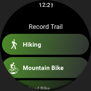
Choose from 50 million hiking, trekking, biking (MTB, road cycling, gravel), trail running, mountaineering, climbing, kayaking, skiing, and up to 80 different types of activities.
Authentic nature trails:
Wikiloc routes have been recorded with GPS and created by community members — nature and outdoor sports enthusiasts like you.
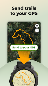
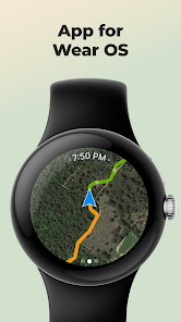
Send routes to your GPS or smartwatch:
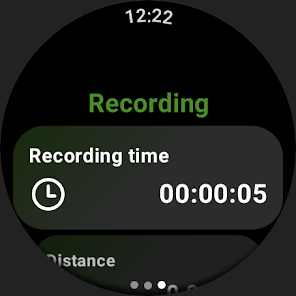
Enjoy the experience from your wrist or mobile. Download Wikiloc routes directly to your Wear OS, Garmin, Suunto or COROSsports watch or bike computer.
Available for devices like Garmin Forerunner, Fenix, Epix, Edge, and many more. You can also record and follow routes on a map from your Samsung Galaxy Watch, Pixel Watch, Fossil, Oneplus, Xiaomi, or TicWatch (minimum Wear OS 3 version).
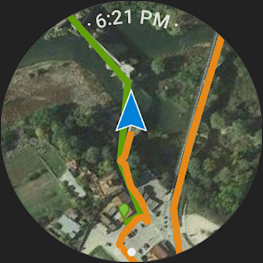
Outdoor Navigation: stay on track:
✅ Turn your mobile phone or smartwatch into a GPS navigator. Your smartphone will guide you with a direction indicator and sound alerts to notify you if you stray off the path during navigation.
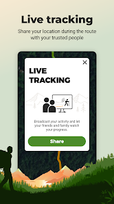
✅ Live GPS route tracking. Share your real-time location with family and friends while you're on the route, so they know where you are at all times.
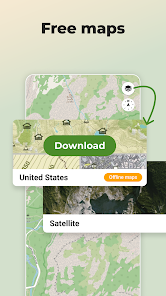
✅ Offline GPS navigation through free topographic maps worldwide for use without coverage or data. Ideal for when you're in the mountains or traveling without an internet connection or with a low battery.
Official routes for all audiences 🏔️🥾♿
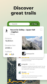
Explore free GPS walking routes through national parks (including routes adapted for reduced mobility and visual impairment), trekking on mountain trails, routes by waterfalls, and more in the largest hiking and cycling community (or bike trails) around you.
Follow local iconic routes on foot or climb the most famous mountain passes. Become part of the community where millions of nature, travel, and sports lovers share their adventures, from the most popular hike to the most remote trekking expedition on the planet.
Find the perfect route for your next adventure, through Premium features such as:
✅ Route Planner: Plan your next adventure easily. Simply choose the places you want to pass through and Wikiloc will create a route prioritizing the most popular stretches of trails from other community members.
✅ 3D Maps: Explore trails with more depth and detail. Without leaving home, discover the terrain relief, evaluate elevation changes, and take a look at the panoramic views that await you along the way.
✅ Advanced search filters: by elevation gain, distance, difficulty, and season (winter/summer).
✅ Search by passing area: find routes that pass through the places of interest you choose and plan your ideal itinerary.
✅ Weather forecast for a perfect outing.
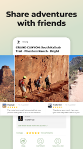
Create and share your adventures
Record your own outdoor routes on a map, add waypoints, take photos of the landscapes along the itinerary, and upload them to your Wikiloc account from your mobile phone. Share your adventures with friends, family, and community followers.
Commitment to the planet
With Wikiloc Premium, you not only help us continue to improve Wikiloc, but you also contribute to protecting the Earth, as 1% of your purchase goes directly to 1% for the Planet, a global network of companies, nonprofit organizations, and individuals working together for a healthy planet.f
Wikiloc is the go-to outdoor navigation application for hiking, cycling, and over 80 other outdoor activities with millions of members worldwide. Find your favorite trails among authentic routes created by the community, record your own and share it, easily transfer it to your GPS device, and more features to enjoy nature whenever you want.
Engage in outdoor sports:
Choose from 50 million hiking, trekking, biking (MTB, road cycling, gravel), trail running, mountaineering, climbing, kayaking, skiing, and up to 80 different types of activities.
Authentic nature trails:
Wikiloc routes have been recorded with GPS and created by community members — nature and outdoor sports enthusiasts like you.
Send routes to your GPS or smartwatch:
Enjoy the experience from your wrist or mobile. Download Wikiloc routes directly to your Wear OS, Garmin, Suunto or COROSsports watch or bike computer.
Available for devices like Garmin Forerunner, Fenix, Epix, Edge, and many more. You can also record and follow routes on a map from your Samsung Galaxy Watch, Pixel Watch, Fossil, Oneplus, Xiaomi, or TicWatch (minimum Wear OS 3 version).
Outdoor Navigation: stay on track:
✅ Turn your mobile phone or smartwatch into a GPS navigator. Your smartphone will guide you with a direction indicator and sound alerts to notify you if you stray off the path during navigation.
✅ Live GPS route tracking. Share your real-time location with family and friends while you're on the route, so they know where you are at all times.
✅ Offline GPS navigation through free topographic maps worldwide for use without coverage or data. Ideal for when you're in the mountains or traveling without an internet connection or with a low battery.
Official routes for all audiences 🏔️🥾♿
Explore free GPS walking routes through national parks (including routes adapted for reduced mobility and visual impairment), trekking on mountain trails, routes by waterfalls, and more in the largest hiking and cycling community (or bike trails) around you.
Follow local iconic routes on foot or climb the most famous mountain passes. Become part of the community where millions of nature, travel, and sports lovers share their adventures, from the most popular hike to the most remote trekking expedition on the planet.
Find the perfect route for your next adventure, through Premium features such as:
✅ Route Planner: Plan your next adventure easily. Simply choose the places you want to pass through and Wikiloc will create a route prioritizing the most popular stretches of trails from other community members.
✅ 3D Maps: Explore trails with more depth and detail. Without leaving home, discover the terrain relief, evaluate elevation changes, and take a look at the panoramic views that await you along the way.
✅ Advanced search filters: by elevation gain, distance, difficulty, and season (winter/summer).
✅ Search by passing area: find routes that pass through the places of interest you choose and plan your ideal itinerary.
✅ Weather forecast for a perfect outing.
Create and share your adventures
Record your own outdoor routes on a map, add waypoints, take photos of the landscapes along the itinerary, and upload them to your Wikiloc account from your mobile phone. Share your adventures with friends, family, and community followers.
Commitment to the planet
With Wikiloc Premium, you not only help us continue to improve Wikiloc, but you also contribute to protecting the Earth, as 1% of your purchase goes directly to 1% for the Planet, a global network of companies, nonprofit organizations, and individuals working together for a healthy planet.f
Updated on
Safety starts with understanding how developers collect and share your data. Data privacy and security practices may vary based on your use, region, and age. The developer provided this information and may update it over time.


Ratings and reviews
4.3
114K reviews

A Google user
- Flag inappropriate
- Show review history
June 6, 2019
The idea is great, and I use the app regularly just to see where other people have gone and where the accessible paths are. The app does have some annoyances and bugs, but there is active support. I have problems planning routes, the map keeps placing blank tiles at random positions. This is being investigated. Filters should be storable. Following a trail has great ideas, like giving a sound when you go off track, which could be improved with settable sounds.
9 people found this review helpful
Wikiloc Outdoor
May 28, 2019
Dear Bert, thanks for your feedback! We are really sorry for the trouble. Please contact us through our support email, we will be able to help you there.

wong yong
- Flag inappropriate
- Show review history
January 22, 2025
Hi, why the trail elevation gain not correct , example , I have record a trail , start is 60m, and trailhead is 260m , but why elevation gain is 122m? Now 2025 year January 22th , wikiloc recording trail is too worst !!! Have many point is lost record , that is very bad experience I'm the paid user ......
2 people found this review helpful

Dave Jackson
- Flag inappropriate
- Show review history
November 24, 2024
The developers, having read and finally taken notice of the customer reviews, have made some improvements to the software that make the app more stable and usable. Congratulations for listening. Update 11/24 This has become my most used Navi App. It still has room for improvements (route planning, map updates from user routes), but is more user friendly than it's competition.
19 people found this review helpful
What’s new
Enjoy the Wikiloc experience from your wrist. Now, record and follow trails on a map from your smartwatch Samsung Galaxy Watch, Pixel Watch, Fossil, TicWatch... (minimum version Wear OS 3.0).
App support
About the developer
WIKILOC OUTDOOR SL
CALLE PIC DE PEGUERA 11
Parc Científic UdG, Giroemprèn, A202
17003 GIRONA
Spain
+34 972 18 33 16


