
PIX4Dcapture Pro: drone flight
50K+
Downloads

PEGI 3
info


About this app
Meet PIX4Dcapture Pro: the drone flight planning app for aerial data acquisition for 2D and 3D mapping and modeling. With its autonomous missions, this easy-to-use solution is a scalable product with professional outputs, including RTK compatibility. Suitable for every industry and powered by the photogrammetry market leaders Pix4D, this is the solution to set you apart as data collection is made easy.
Features highlights:
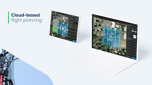
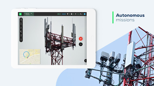
• Create missions from the mobile app or plan missions using the desktop and cloud-based platform PIX4Dcloud with its Mission Planner tool.
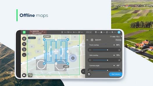
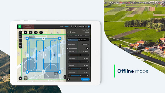
• Offline maps* - plan missions in advance and download basemaps to have a visual reference when flying offline in the field.
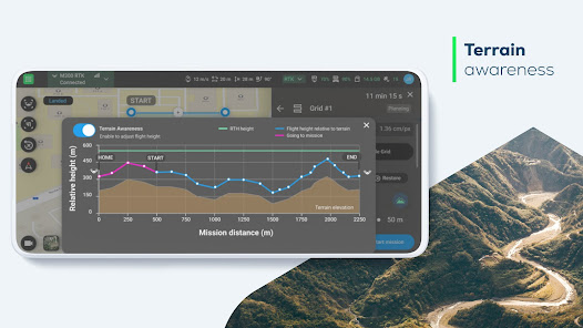
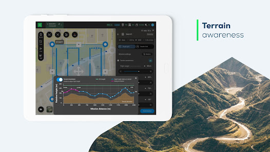
• Terrain awareness - the drone follows the terrain to enable optimal processing for the best possible results.
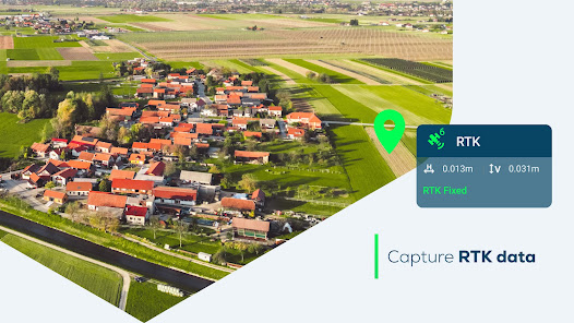
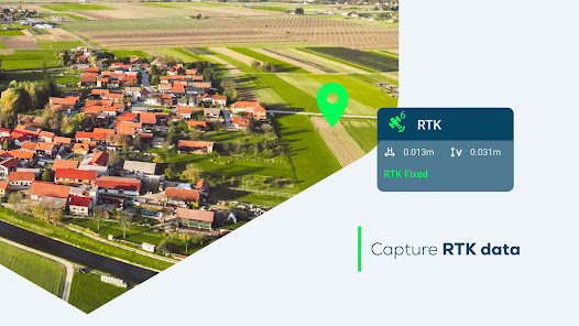
• Achieve centimeter accuracy with RTK drone support.
*Please note that you need to have the offline maps to enable the Terrain awareness feature.
Workflow:
1- Create a mission or plan on a cloud based platform with PIX4Dcloud’s Mission Planner tool**
2- Fly your drone!
3- Upload and analyze your data on the PIX4Dcloud platform or any desktop software by Pix4D
**Please note that a valid PIX4Dcloud license is required. A free 15-day trial is available.
Drones compatibility:
• DJI
- Mavic 3E***
- Mavic 3T (RGB only)***
- Mavic 3M***
- Mini 3/Mini 3 Pro***
- Matrice 300 RTK***
- Phantom 4 Pro V2
- Phantom 4 Pro
- Phantom 4 RTK
- Phantom 4
- Mavic 2 Pro
- Mavic 2 Zoom
- Matrice 210 RTK V2, 210 V2, 200 V2
- Matrice 210 RTK, 210, 200
• Parrot
- Anafi USA with Skycontroller 3 and Skycontroller USA (RGB only)
- Anafi Thermal with Skycontroller 3 (RGB only)
- Anafi with Skycontroller 3
***Compatible version available from our support page.
Usage information:
Ensure you have the latest firmware installed and the application is up to date. The application follows the flight plan and does not avoid obstacles automatically. Pix4D accepts no liability for damage, injuries or legalities from the misuse of this application. Use only in safe environments.
Features highlights:
• Create missions from the mobile app or plan missions using the desktop and cloud-based platform PIX4Dcloud with its Mission Planner tool.
• Offline maps* - plan missions in advance and download basemaps to have a visual reference when flying offline in the field.
• Terrain awareness - the drone follows the terrain to enable optimal processing for the best possible results.
• Achieve centimeter accuracy with RTK drone support.
*Please note that you need to have the offline maps to enable the Terrain awareness feature.
Workflow:
1- Create a mission or plan on a cloud based platform with PIX4Dcloud’s Mission Planner tool**
2- Fly your drone!
3- Upload and analyze your data on the PIX4Dcloud platform or any desktop software by Pix4D
**Please note that a valid PIX4Dcloud license is required. A free 15-day trial is available.
Drones compatibility:
• DJI
- Mavic 3E***
- Mavic 3T (RGB only)***
- Mavic 3M***
- Mini 3/Mini 3 Pro***
- Matrice 300 RTK***
- Phantom 4 Pro V2
- Phantom 4 Pro
- Phantom 4 RTK
- Phantom 4
- Mavic 2 Pro
- Mavic 2 Zoom
- Matrice 210 RTK V2, 210 V2, 200 V2
- Matrice 210 RTK, 210, 200
• Parrot
- Anafi USA with Skycontroller 3 and Skycontroller USA (RGB only)
- Anafi Thermal with Skycontroller 3 (RGB only)
- Anafi with Skycontroller 3
***Compatible version available from our support page.
Usage information:
Ensure you have the latest firmware installed and the application is up to date. The application follows the flight plan and does not avoid obstacles automatically. Pix4D accepts no liability for damage, injuries or legalities from the misuse of this application. Use only in safe environments.
Updated on
Safety starts with understanding how developers collect and share your data. Data privacy and security practices may vary based on your use, region, and age. The developer provided this information and may update it over time.


What’s new
What's new:
- Fix support contact email.
- Updated support links.
- Fix support contact email.
- Updated support links.
App support
About the developer


